EXPANDED CAPITAL CITY & THE METROPOLITAN PLANNING AUTHORITY
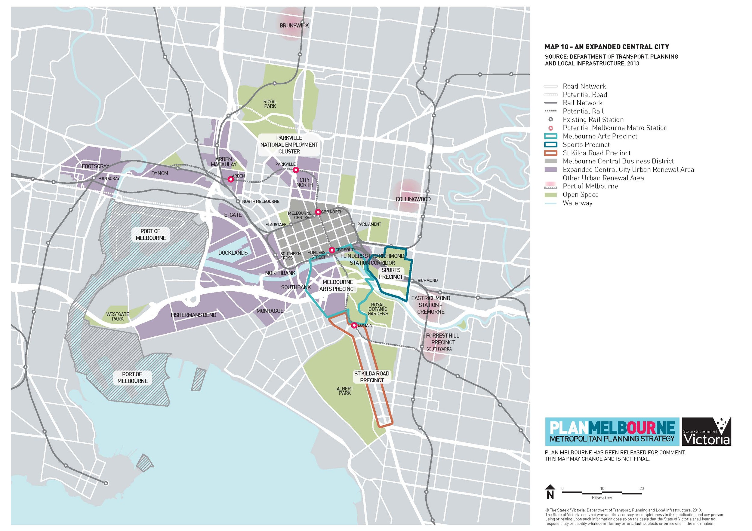
Fig.1. The Expanded Capital City according to Plan Melbourne October 2013
by Gerry McLoughlin, Architect, Urban Designer and Secretary of IMPA.
The term Expanded Capital City first emerged around the time of the current Coalition government came into office in 2010.
In July 2012, with the City of Melbourne Amendment C170 and the City of Port Phillip Amendment C102, the powers of the Minister for Planning were widened as the Responsible Authority for the Fishermans Bend Urban Renewal Area under zone CCZ or Capital City Zone. The areas described as the Expanded Capital City, which is not a planning zone definition, was loosely discussed in government and planning circles but not clearly defined as there were no diagrams to indicate the extent or at least no diagrams available to the public.
Fisherman Bend Urban Renewal Area (FBURA) was rezoned CCZ July 2012 under Section 20(4) of the Planning and Environment Act 1987 – Melbourne Planning Scheme Amendment C170 and City of Port Phillip Planning Scheme C102.
Amendment C170 or C102 did not have diagrams only text references to the defined area so there was no clear definition of what was defined as the Expanded Capital City.
Fig.1 emerged with the release of the PLAN Melbourne draft document in October 2013 which defines the Expanded Capital City area and includes areas now defined by C170 & C102 Planning Amendments as Capital City Zone (CCZ1) areas of Fishermans Bend.

Fig.2 Diagram from DPCD website 2011
The area defined as the Expanded Capital City in PLAN Melbourne’s diagram takes in:-
o Fishermans Bend
o Arden MaCaulay (Kensington)
o E-gate
o Docklands
o Southbank
o Northbank

Fig.3. Diagram from FBURA Visions Document - September 2013
o Flinder Street station to Richmond Station and corridor
o Footscray and Dynon (West Melbourne)
o City North (parts of Carlton and Parkville)
o Melbourne Arts Precinct
and other urban renewal areas including
o Brunswick
o East Richmond / Cremorne
o Collingwood
o Forrest Hill, South Yarra
The first diagram of what was referred to as the Expanded City Limits (Fig.2) was noted on the DPCD website in 2011 and referred to areas where the city activity had expanded. The proviso under the diagram was that it had no formal status and was simply a diagram representing activity spread of a city nature.
Fig.3 This diagram was contained in the Fisherman's bend Urban Renewal Area documentation to illustrate the extent of "Central Melbourne's Growth".
Not until the release of Plan Melbourne do we get to see the full extent of the Expanded Capital City.
COMMENTS - Key points
FBURA – City of Melbourne C170 & City of Port Phillip C102
- Amendment C170 of Melbourne Planning Scheme refers to the Lorimer Street Precinct which is generally bound by Lorimer Street, Graham Street and the West Gate Freeway in Docklands/ Port Melbourne. A separate Amendment C102 to the Port Phillip Planning Scheme is proposed for the Montague Street, Plummer Street, Fennell Street Precincts).
- The 4 precincts of the Fishermans Bend Urban Renewal Area (FBURA) in the July 2012 C170 Melbourne Planning Scheme Amendment and C102 City of Port Phillip Planning Amendment giving the Minister for Planning the Responsible Authority rights is referred to as part of the Expanded Capital City. We see the same status apportioned to a number of other areas of inner Melbourne in the FBURA diagram (September 2013), and the diagram in the draft PLAN Melbourne (Oct 2013) with significantly wider area included.
- The question has to be asked - under what powers will the Minister use to include the other areas now nominated as part of the Expanded Capital City?
- FBURA is seen to be largely a land speculation market – limited prospect of urban renewal in the near future as there is no State Government budget commitment for soft or hard infrastructure
- Urban Renewal objectives have significant conflicts with Port of Melbourne Upgrade objectives
Metropolitan Panning Authority
The Metropolitan Planning Authority was launched 9 October 2013. This is largely a re-badging of the Growth Area Authority with the inclusion of a new group covering Inner Melbourne, but with many of the same personal – Peter Seammer CEO (previously CEO of Places Victoria and GAA since 2007) , Steve Dunn Director of the South EAST also since 2007.
MPA includes six teams including Inner City: This team, headed by our newest director Jane Monk, will work within the inner city councils implementing key items listed in Plan Melbourne
The MPA has undergone an organisational restructure to ensure that it is best placed to deliver on its expanded role and focus on implementation of Plan Melbourne.
Jane Monk appointed the newest Director of Metropolitan Planning Authority for newly established Inner Melbourne group; announced November 2013 and expected to start the role in January 2015.
Jane Monk joins the MPA from DTPLI, where she most recently served as Director of Planning Statutory Services. Jane has an extensive background in urban planning, having worked in local government before becoming a senior member of VCAT and then to the Department. She is well known within the industry and is currently Vice President (Planning) of VPELA.
- Ms Monk, indicated at a CEDA lunch (28 February 2014) that Responsible Authority status will transfer from the Minister for Planning to the MPA in due course for the FBURA area and other urban renewal areas within Inner Melbourne.
- Ms Monk, also stated that the Development Contribution Provision for FBURA is $15900 per dwelling. With the Government estimation of 80,000 new residents with an approximation of 40,000 new dwellings that will equate to $64million in DCP contributions which will not see anywhere near the level of funding that will be required to establish a 240 hectare urban renewal area
MPA are understood to be under resourced
The MPA is the intended delivery mechanism for PLAN Melbourne, the Victorian Government’s strategic plan for metropolitan Melbourne to 2050.
Plan Melbourne strategic primary directions, initiatives and short, medium and long term actions for infrastructure, housing, employment, the environment, an integrated land use, transport and social infrastructure to meet the demands of population growth and climate adaptation are set out in the following principles:
o A more connected city – a public transport rich connected city.
o Housing choice and affordability including social, affordable and the full range of housing types.
o Liveable communities and neighbourhoods – the 20 minute neighbourhood.
o Sustainable environment and water.
o Growing rural cities where infrastructure and natural resources can tolerate it.
IMPA supports these general principles however, IMPA calls for the introduction of detailed urban design processes which currently do not occur and are not required by the Planning & Environment Act.
Without detailed research and design processes the aspirations of PLAN Melbourne with not be achievable
Further IMPA is concerned about the extent of the Expanded Capital City without strategic planning and design visioning or planning controls that reflect the values and aspirations for future Melbourne and the extent of the Minister’s powers for this vastly extended area.
The community including professionals, business, academia and the general public have largely been left out of any part in the definition of the Expanded Capital City area and its stated ambitions articulated in the Minister for Planning’s Press Releases and the draft PLAN Melbourne document.
RECOMMENDATIONS
IMPA supports:
- That the Metropolitan Planning Authority be politically independent, with a strategic policy and long term planning brief
- The establishment of the 5 metropolitan subregions including the central subregion which takes in the IMAP Councils (i.e. the Cities of Melbourne, Port Phillip, Stonnington, Yarra and Maribynong).
- The development of a central sub region strategic framework plan as a priority. This framework should be in sufficient detail and have the planning clout to identify and secure key strategic public interests sites and opportunities in a timely fashion for the Expanded Capital City Zone and other urban renewal areas.
- Halting of the E-W Link process until a thorough review can be undertaken for Part A and B of the proposed link (see IMPA Briefing Note on E-W Link) We note that Part B (Parkville to Port Melbourne) is premature and support the City of Melbourne position that there are a number of more pressing transport infrastructure priorities in the short to medium term such as Melbourne Metro, tram network development and airport rail
JUSTIFICATION
IMPA notes the following issues and opportunities with key aspects of PLAN Melbourne
- The establishment of the ‘Integrated Economic Triangle by 2050’ (linking the Hastings Dandenong corridor with the Hume corridor and the Wyndham-Geelong corridors to the south-west, expanded capital city with major corridors of Hastings Dandenong corridor with the proposed E-W Link through the Expanded Capital City) will consign the state to a road based freight system with substantial freight traffic (2 million more freight journeys) through central Melbourne. The two key current infrastructure projects; the $1.6b Upgrade of Port of Melbourne and the $6-8b E-W Link have substantially had no. or limited. community involvement.
IMPA calls for a review (inclusive of all stakeholders) of these projects in light of the Eddington Report (2008)
- A Pipeline of Investment Opportunity to the private sector to finance soft and hard infrastructure to FBURA, E Gate, Arden Macaulay, City North, Dynon, the Flinders St and Richmond station corridor and major transport initiatives such as Metro 1.
IMPA calls on the state government to share the load of providing for infrastructure, as it has traditionally done, to complement the newly proposed development DCP in order that infrastructure is delivered in a timely fashion and leads renewal programs
- A more sustainable city in the areas of water and waste management, building performance, energy generation, urban farming and climate change adaption.
IMPA supports elevating this to a high priority across all new buildings and public space projects in the city growth program
- Housing Choice and Affordability to be developed into a Plan as a short term priory
IMPA supports the development of a social housing and affordable housing Plan elevated to a short term priority for the urban renewal areas.
- Protecting existing suburbs by delivering density in defined areas of FBURA, E Gate, Arden Macaulay, City North, Dynon, the Flinders St and Richmond station corridor.
IMPA calls for a refinement of the definition of density models to best suit the needs of a liveable city. Such definition should be developed with all stakeholders, including community representatives
REFERENCES
o PLAN Melbourne
was released 9 October 2013 - Submissions closed 6 December 2013
http://www.planmelbourne.vic.gov.au/
o for further information on the Metropolitan Planning Authority visit the following website
http://www.planmelbourne.vic.gov.au/
o Melbourne City Count Planning Amendment C170 July 2012
o City of Port Phillip Planning Amendment C102 July 2012
http://dsewebapps.dse.vic.gov.au/Shared/ats.nsf/WebViewUniqueID/AC442C3558A081B7CA25785B007B3CD7?Opendocument&P&Port+Phillip&Port%20of%20Melbourne,Port%20Phillip,Pyrenees
and
http://www.portphillip.vic.gov.au/en/amendment-c102.htm
o for updates on Planning Applications go to
http://dsewebapps.dse.vic.gov.au/dse/planning/phbppat.nsf/InternetAppListing?OpenView
o CCZ1 – Capital City Zone definition
http://planningschemes.dpcd.vic.gov.au/search?q=CCZ1
The following zone planning diagram indicate the current extent of the Capital City Zone CCZ1 – 3 area

Image from http://services.land.vic.gov.au/maps/pmo.jsp